Showing posts with label Chaco Phenomenon. Show all posts

Thursday, September 5, 2013

Great Sites: Weatherill Mesa

Mesa Verde National Park

 
Weatherill Mesa is remote and, therefore much less visited than the rest of the sites at Mesa Verde National Park.  But it is a real treasure to visit. 
Long House at Weatherill Mesa
Mesa Verde National Park
 
There are three main attractions, 1) the Ranger guided tour of Long House, 2) the Loop facilitated by the tram, and 3) the hike to the Step House site.

The Ranger guided tour of Long House is a must.  This site was unique for a cliff dwelling because of its large open-air plaza fashioned after a large kiva and the natural seep spring.  


The tour begins with a short ride on the tram to a covered area with picnic tables.  You follow the Ranger down a steep switch-back trail to the site.
 
At first, Long House doesn’t look like much, but you soon learn that there are a lot of very interesting and unique features.
 
A ladder takes you up into the upper level where the Ranger points out an area where they ground their stone axes on the sandstone.


There are also imprints of corn cobs in the plaster—maybe made by kids playing because further down are hand prints on the walls made by small children. 
 
 
Some commented that it reminded them of a day-care facility.


Up in this balcony area you see one of the features that I find fascinating—a seep spring.  Rain and snow melt seeps through the porous sandstone that makes up the alcove.  When it hits the slate layer, it seeps out into the alcove providing a natural source for water right in the dwelling.


Looking down on the plaza you can see another fascinating and unique feature of Long House—the open-air plaza.  It looks like a grand kiva with the walls and roof missing.  Here is a partial transcript of Ranger Sam's eloquent description of how the plaza was used. [video of presentation]
 
"For 700 years  after the Ancestral Puebloans left Long House, this is all [there was to] Long House [peaceful and quiet].

"But back in the day, when the Ancestral Puebloans lived here, this place would have been alive with the sound of people, with the sound of the community—songs, dancing, singing, laughter, especially this place where we are standing right now.  We call this place, this courtyard, the Great Plaza  or the Great Kiva.

"I like to imagine that over this [rectangular rock-lined] opening here and this [rectangular rock-lined] opening here,  they have stretched skins of deer skins or elk hides. And this is a drum, and they are beating drums and making music.  

"And over here [this big square pit] is a fire pit and they have a big fire going and they are singing and dancing around that communal life force, the fire.

"Over here [behind the fire pit] we have another interesting little hole in the ground and this is what is called a Sipapu, and “sipapu” means place of immergence.   And this little hole, or square I should say, represents where these people believe that their Mother, the Earth, had given birth to them up to the surface to meet their father, the sky, and this Sipapu is where they believed their spirit would go back into the earth when they died.

"And over here we have more drums.  There are people laughing, singing and dancing.   This place is alive with the sounds of the community.  And what is so great about this story is that although that sound, that laughter, that talking may not be here in Long House today, it is still going on.  So what happened to these people, where did the Ancestral Puebloans go?

"Well they were dry land farmers, right?  So they depended upon the rain for water for their crops.  So, what happens when it stops raining?  Their crops failed and you can’t eat.  And that’s what happened to these people in 1280, a drought struck this region that lasted almost 30 years.  They couldn’t eat and they couldn’t make do, so they had to put art and architecture aside and renew."

[They abandoned the cliffs and moved south to start over.]
 
 
After the Long House tour, you can catch the tram for a Loop trail around the mesa.  The Loop was fun.  There are nicely preserved pithouses protected by metal buildings.  The tram lets you out at the paved trail-head and then picks you up at the end of the trail.  There are some parts of the tram ride where the driver waits for you to look at cliff dwellings from the rim.


Then there is the hike to Step House.  Unfortunately, we got rained out of our hike to this unique site.  I really wanted to see this site because there is a reconstructed pithouse, a large concentration of rock art, and the ruins of two separate occupations side-by-side. 
 
I will be going back to Mesa Verde National Park and you should visit it, too.  This is archaeology at its most elegant and beautiful.  It is probably the last site of the Ancestral Pueblo Culture, the culture that was part of the Chaco Phenomenon that lasted for over 500 years.  It was a culture that rose to great heights in art, architecture, government, and social life.  There is every reason to believe that the people were happy, healthy, and prosperous.  It was a good life with little signs of war or conflict.  Their's was a culture to be admired, studied and learned from.
 
by Courtney Miller
 
My book, The First Raven Mocker, has just been released. 
 
 
See what the Cherokee were like in mythological times.
 
Check it out at:
 

Thursday, July 18, 2013

Great Sites: Aztec Ruins National Monument: Mini Tour

What is there to see at Aztec ruins?  Aztec Ruins National Monument is a small place, but has a big offering.   The restored great kiva is worth the visit by itself but there are also well preserved rooms with the ceilings intact, great examples of fine Chaco-style architecture, and it is easily accessible.  Let me give you a sample with this mini tour [Note: this week you have the option of watching a video with each section]:

[video] The great house, Aztec West, is only a few steps from the visitor center.  In the 1100’s it was a three-story building with over 500 rooms and many kivas including the restored great kiva in the plaza.  Right away you come face-to-face with the west wall where the significance of unique green rows of greywacke stone hauled from nearby quarries is a mystery.  We can only guess at reasons for the inclusion by the original masons. 

[video] As you follow the trail along the west wall  [of the Aztec West great house] you can peer into some of the outer rooms.  Most of the rooms were for storage, some were burial chambers, and one has a vented chamber suggesting it may have been a residence.

[video] We are now inside the great house at Aztec Ruins where the visitor trail allows us to explore
the rooms along the back wall.  Many of the ceilings are original construction that has survived the ages.  This One room was a burial chamber with over a dozen bodies found wrapped in shrouds of feathers or cotton cloth and rush matting and accompanied by offerings of pottery, jewelry, clothing and other items.  Many of the rooms were burial chambers with one or sometimes many corpses.  Other rooms were for storage and some contained trash heaps. 

[video] Two rooms in the Aztec Ruins Great House are very interesting.  One room once contained a door, but then the room was sealed off.  Perhaps it was a burial chamber or was filled with trash and access was no longer needed.

Next to the sealed off room is a square room that has many of the characteristics of a kiva including benches around the outside and a vent chamber on the south side.  All kivas were built inside a square room, but this one is missing the characteristic enclosed, round walls.  Maybe it was just too small.

[video] T-shaped doors became common in Chaco-style great houses after being introduced by the Mesa Verde outliers.   They look strange but had an exquisitely practical function.

They were built this way so that occupants carrying a load from the plaza with their arms full could easily enter the room.
 
[video] In one of the two great kivas in the plaza at Aztec Ruins, The timbers resting atop one another demonstrate the lower part of a domed, cribbed roof.  A cribbed roof uses many more large timbers than a flat, horizontal roof so archaeologists  believe that Chacoan kivas with domed roofs were used less often.   The restored great kiva across the plaza demonstrates the more traditional flat roof.

[Video] The reconstructed great kiva is what Aztec Ruins is most famous for.  

After Earl Morris excavated the great kiva in 1921, exposure took its tole and it weathered away.   So, the park service decided that rather than bury what was left, they would bring Mr. Morris back to consult on the reconstruction.  Everything in the reconstruction is based upon evidence Morris had found in his excavation.

The huge room could have held hundreds of people.  A smaller room may have hidden the performers while people entered.  The main room had a square floor vault where the sacred fire greeted guests entering from the south.  Two large, rectangular foot drums would have echoed loudly as dancers stomped on would covers. 

[Video] The main room of the great kiva was built to facilitate impressive productions.  Sacred fires crackled from the square hearth.   Foot drums of different sizes produced different sounds as the dancers stomped on them.  The four sandstone discs originally supported each of the four pillars to keep them from settling under the weight of the massive roof.  Small rooms encircled the main room with ladder access.  Perhaps to enable dancers to flood dramatically into the room?

[Video] Encircling the main room of the great kiva at Aztec are small antechambers.  Someone could descend into the room by using the ladder built in to the wall.  The room also had a door to the outside.
 
By the late 1200's, the Ancestral Pueblo culture in Aztec like the other Chacoan great houses gave up on this site and abandoned it.  The people moved south and established new pueblos as the Zuni, Hopi, and Navajo cultures of today.

-- Courtney Miller


Want more?  Watch this five-part video tour by Ranger Tracy Bodnar

Thursday, July 11, 2013

Great Sites: Aztec Ruins National Monument, Introduction

Aztec ruins in New Mexico?  Were the Aztec ruins really built by the Aztecs?  No, the Aztec ruins in northern New Mexico were built by the Ancestral Puebloan people, but early settlers thought they must be Aztec buildings and the name stuck.
Courtney Miller
Aztec Ruins National Monument

This week I want to share my recent visit to Aztec Ruins National Monument with you.  It is an amazing archaeological site, a friendly and easily accessible National Monument, and an important historical landmark with a wonderful story.  Aztec Ruins National Monument is located on Ruins Road about ½ mile north of New Mexico Highway 516, in the City of Aztec, New Mexico near Farmington and Durango, Colorado.

As stated on the Park's website ( http://www.nps.gov/azru/index.htm )“Pueblo people describe this site as part of their migration journey. Today you can follow their ancient passageways to a distant time. Explore a 900-year old ancestral Pueblo Great House of over 400 masonry rooms. Look up and see original timbers holding up the roof. Search for the fingerprints of ancient workers in the mortar. Listen for an echo of ritual drums in the reconstructed Great Kiva.”

Aztec Ruins National Monument is open 8:00 a.m. to 5:00 p.m. most of the year and 8:00 a.m. to 6:00 p.m. Memorial Day weekend through Labor Day. The park is closed Thanksgiving, December 25th, and January 1st.
 

The restored Great Kiva, pictured to the left, sits in the courtyard of the Great House.  It wasn’t really a House so much as a community.  Ancestral Pueblo people at Aztec planned and built it but were greatly influenced by The Chaco Culture 55 miles to the south.  At first Aztec may have supported Chaco Activities.  Later it may have been a center in its own right when Chaco‘s regional influence waned after 1100.


In addition to the Great Kiva, Chacoan-style Great Houses also had many smaller kivas used by kinship groups.  Pictured above is a typical "keyhole"  kiva. Note the six stone pilasters used to support the cribbed roof.  A square hole in the center of the roof allowed guests to enter and smoke to escape.

The niche in the south wall gave the kiva a “key-hole” shape and provided  a vent to the outside.  The users would sit on the benches around the firepit near  the center.  Across the firepit opposite the “niche” there would have been a small hole in the floor called a Sipapu.  It is covered by back fill here.  This honored the ancestors who ascended from the underworld. 
 
Next to the keyhole kiva is another one that is not typical.  This one does not have the niche, just the vent.  All the kivas were slightly different which was probably reflective of a different kinship group.
 
 
Aztec’s population ebbed at times but persisted through cycles of drought and cultural changes in large part thanks to the Animas river that flowed year-round.  It  still flows just beyond the visitor center.


Thursday, June 27, 2013

Great Sites: Chaco Culture National Historical Park: Part 3: Chetro Ketl

Chetro Ketl
Original Collonades are filled in

 
Mayans in New Mexico?   In the Chaco Culture National Historical Park there is a Great House built by the ancestral Puebloan culture that is a glaring example of the influence of the Mayan culture.  If you look closely at the front wall facing the plaza at Chetro Ketl, you can see that it “was originally built as a row of masonry columns which once held horizontal timbers to support a roof over an open cloister-like porch.”   This quote is from the guide book provided by the NHP.  It goes on to say, “Sometime later the spaces between the columns were filled with masonry to completely close the passageway.”  And later the area was divided further into smaller rooms.
Chetro Ketl
Artist's Rendering by Courtney Miller
 
To give you an idea of what it would have looked like originally, I have drawn a sketch with the porch as it was before it was filled in.  “Pillars and colonnades are features of prehistoric architecture in central Mexico, but were unknown to the American Southwest before the Bonito Phase.”  Note the similarity of style in the drawing with the buildings in the Mayan city of Palenque.  This is just one more piece of evidence that there was extensive trade between the Chaco Culture and the Central American cultures.


Mayan building in Palenque
Note colonnaded porches
Chetro Ketl is due east of Pueblo Bonito.  A line extended from the front wall of Pueblo Bonita bisects the heart of Chetro Ketl and they are clearly visible to each other.   There are many similarities between the two, but some striking differences as well.  Chetro Ketl’s floor plan is more the traditional rectangular design as opposed to the unique “half moon” shape of Pueblo Bonito. 


Chetro Ketl was also the termination point of three great roads.  Just to the northeast an ancient stairway hewn into the canyon wall led to a prepared roadway at the top of the bluff.  This road once led north to the village known today as Aztec ruins.  Due south there is the remnants of another stair leading out of the valley and connecting with a north-south road that led to the southern outliers.   
 
West and a little south there is the remnant of a stairs that once connected to a short road to the Great House “Pueblo Alto”.  Watch a video on this stairs.  You can still see the final steps terminating in one room, part of a small house of about 30 rooms and five kivas.  All that remains of the stairway above the house are the holes where supports were placed and a few stairs hewn in the rock cliff.  Above the bluff a 16-20 foot road led to Pueblo Alto.  Typically, the first stop for visitors.  The steps would have landed on the roof of the back room and then a grand rock staircase would have brought the visitor into the front room.  A regal entrance onto the canyon floor just behind the Great House, Chetro Ketl.

The ancestral Puebloans built over 200 miles of roads connecting most, if not all, of the pueblos of the Chaco world.  These roads were 16 to 20 feet wide and bordered by berms of soil or loose rock and often filled with soil to keep them level .  “The roads are not simple trails following the easiest routes, but are straight for miles, connecting points not in sight of one another, and disregarding rough terrain.”

Chetro Ketl also hosts both subterranean Kivas, which are common and tower Kivas built on the third floor which was peculiar to this era in the canyon.  See the Kivas.

Chetro Ketl is a fascinating site to visit and should definitely be on your list when you visit Chaco Culture National Historical Park.

Thursday, June 20, 2013

Great Sites: Chaco Culture National Historical Park, part 2: Pueblo Bonito

Aerial view of Pueblo Bonito
It is the largest of the Great Houses at Chaco Canyon and possibly the largest anywhere in North America.   It is the most thoroughly investigated and excavated and there is good evidence that the massive structure was intricately pre-planned down to its odd placement in the canyon.  For instance, the thickness of the walls on the ground floor rooms indicate that it was planned to be five stories high from the beginning although construction, started in 850 A.D., would take 200 years to complete.


Aerial view of Pueblo Bonito
Note the remains of "Threatening Rock"
in upper right
And it was placed too close to the canyon wall indicating that its placement was based on a higher
purpose.  Despite a large piece of the canyon wall, later named “Threatening Rock”,  that had broken loose and would undoubtedly fall someday, they stubbornly stuck to their plan.  Threatening Rock did come down and knocked out a good portion of the back wall January 1941 (note the rock pile in the lower left of the picture above).  Something about that spot made it critical that it be placed there.


What is the structure?  It is Pueblo Bonito at Chaco Culture National Historical Park in northwestern New Mexico.

Another interesting anomaly is the design of Pueblo Bonito.  The floor plan is in the shape of a “D” or, as our tour guide pointed out, a “half moon”.  Looking at the aerial view are you seeing another striking similarity to the moon?  The craters?  Well, before we get too carried away, the round kivas would have been covered!   Most Great Houses were square or rectangular or, if they had a curved wall, it was in front of the courtyard.  But almost always, the back wall was straight. (Of course, other would be houses that were unplanned or built on covered ledges like at Mesa Verde).   At Pueblo Bonito, the entire back wall is curved and the wall in front of the courtyard is straight. 


Tour of Casa Rincanada
Canyon wall between Pueblo Bonito and Chetro Ketl
is in the background
 
An interesting phenomenon resides between Pueblo Bonito and Chetro Ketl, the Great House to the east, according to our guide.  This cliff face produces great acoustics.  The field between Pueblo Bonito and Chetro Ketl showed signs of use, but was not used for agricultural purposes.  Our guide speculates that it was a community gathering place.  The sound from drums and flutes played next to the cliff face would have carried across the valley.


Although Pueblo Bonito probably contained over 800 rooms in its heyday,  research suggests that very few people lived in the Great Houses permanently.  For instance, there were very few burials found in the canyon.   This would suggest that the Great Houses in Chaco canyon were more like resorts than villages.  Goods from all over the southwest, Central America, and the east support the theory that Chaco Canyon was a central trading hub.  It is more likely, that people came to the canyon to trade their goods and while there experience the lavish ceremonial events staged in the Great Kivas, large dance fields, and great plazas.

Pueblo Bonito would have been a most impressive place to visit back then.  With the best architecture and construction, oversized rooms,  grand courtyards, huge Kivas, and massive storage facilities, it would have been a spectacle.   It was like no other place in the southwest.  Even in a canyon where Great Houses dotted the valley and canyon rims, it was (and is) unique.

Imagine approaching this enormous, five-story “hotel” covering three acres with an enormous courtyard in front where dancers in brightly colored costumes were dancing to the thundering beat of massive foot drums, melodious flutes, rattles and chanting singers.  A massive round Kiva sitting in the center of the courtyard held impressive ceremonial rituals.  I imagine that it might have been like going to New York City on business and taking in Broadway plays and shopping.


A SIDE NOTE:

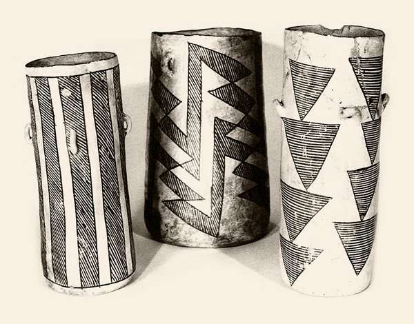
These cylinder jars from Pueblo Bonito contained chocolate!  It was in liquid form and imported from Central America for elite guests.  In some Maya ceremonies a cacao beverage was frothed by pouring the liquid from one vessel to another.  The Maya were known to ground cacao beans, mix them with spices, chilies, and water, and frothed the drink for consumption either hot or cold.  In addition to this exotic drink, trade with Central America included rare Quetzal feathers and parrots.


Thursday, October 25, 2012

Inconvenient Arrogance, Part 6 – The Collapse of the Chaco Phenomenon


Great Kiva - Pueblo Bonito
“It is not hard to imagine one of these ancient villages—the adults going about their tasks, the children playing or learning at their side.  We can almost smell the rabbit stew cooking in the earthen pot and the aroma of corn roasting over the coals of the cookfire;  we can almost see the freshmade paper-thin piki bread—all this in anticipation of the day’s-endmeal after the men have returned from attending to the fields or building a new village structure.” – Kendrick Frazier, “People of Chaco”.


Life among the Anasazi was hard but they were a rugged and industrious people who by the twelfth century had created great stone houses and temples and created governments that organized and distributed their commodities and coordinated trade.  Although the most prominent and powerful, the Chaco culture was not alone in the Southwest.  In Arizona, the Hohokam society built smaller stone houses and made extensive use of canals for farming.   East of the Hohokam, the Mogollon society had a similar culture.  In between Chaco and Hohokam and Mogollon, a hybrid society that borrowed canal technology  from the hohokum and architecture from Chaco were called the Mimbres.  During the classic period, trade was pervasive among these different cultures.

Penaco Blanco -- Chaco Canyon
Road that defines Chaco Meridian

So, what happened to Chaco Canyon?  Why was it vacated by A.D. 1170?  Evidence shows that climate change resulting in long periods of drought is at the root of the cause.  Long before, Chaco Canyon had become over populated and unable to sustain itself without the aid of the outliers.  The luxury of being the central storehouse for the region and in control of distribution allowed them to skim off the extra they needed.  Since corn could only be stored for three years, however, any drought lasting longer than three years depleted the store houses and left Chaco Canyon unable to sustain itself or redistribute to outliers needing help.  This made the outliers unwilling to share their surpluses with Chaco Canyon and hoard their crops for themselves.  The collapse was amazingly swift.

Where did they go?  Jared Diamond proposes, “By analogy with historically witnessed abandonments of other pueblos during a drought in the 1670-‘s, probably many people starved to death, some people killed each other, and survivors fled to other settled areas in the Southwest.”

But, unlike the Maya and the Moche, the rulers of Chaco did not resort to human sacrifice to stave off their demise.  There are several reasons that they never rose to this level of cruelty.  The lace of a large centrally controlled military made enforcement from Chaco impossible.  There are signs that there were violent skirmishes at outlier sites, but not on the scale that would suggest a large military invasion.

Stephen Lekson offers a unique  alternative.  In his book, “The Chaco Meridian”, Lekson suggests, “The end of Chaco was a major event over the entire Pueblo world.  Far to the south, for example, the Mimbres achievement ended at the same time. … The Chaco capital moved to the north …”  The Chaco elite, according to Lekson, re-established the Chaco system along the Las Animas river at the site called Aztec.  Again from Lekson, “Aztec continued the traditions and forms of Chaco, but ruled a diminished realm …”

What is unique about the Lekson hypothesis is that Aztec lies along the meridian that intersects with Chaco and a road follows that meridian from Chaco to Aztec.  Even more remarkable, after the fall of Aztec in A.D. 1275, “The Elite moved completely off the Plateau, through the vacant despoiled Mimbres country and into an empty niche, ripe for major canal irrigation.  They built their new city, Paquime, on the Rio Casas Grandes.” 
 
Which, remarkably, lies along the same meridian!

Thursday, October 18, 2012

Inconvenient Arrogance, Part 5: The Chaco Phenomenon

Pueblo Bonito -- Chaco Canyon
from the rim
When the current Southwestern cultures reach back in their lore to their origins and refer to the “White House”-- “places of wonder and tragedy”, they are probably referring to the great pueblo houses at Chaco Canyon.  Pueblo Bonito, the largest of the “Great Houses” was five-stories high, covered over two acres, contained over 650 rooms, 45 small kivas and two “Great Kivas”.  Kivas were large, round pits or chambers used for religious and ceremonial events.

Stephen Lekson, who has studied the Anasazi phenomenon for over twenty years, described Chaco Canyon this way in a recent article for National Geographic, "Imagine that you're a teenage kid in the 11th century, coming from the boondocks to Chaco for the first time.  You've walked four days from the north across that desolate plain to get here and you look over the edge . . . what would you think?  It would scare the hell out of you … They planned it that way—as theater."
Great Kiva at Chetro Ketl
Note: hidden chamber in back enabled underground
passage to center of kiva for theatrical entrances

Within its thirty-two square miles, there were thirteen of these great houses!  If you have ever driven through the heart of New Mexico, which is where Chaco Canyon resides, you have to admire the raw beauty of the arid lands.  But it is hard to imagine that anyone could etch out a living there.  Even today, houses are few and far between.  But in its heyday, it was estimated that over 5,000 lived in Chaco Canyon.

I think that the harsh conditions may have contributed to the extraordinary achievements because in order to survive they had to be extraordinarily creative and resolute.   But why build there in the first place?  Initially, it was a favorable location for that part of New Mexico since the narrow canyon caught rain runoff from the upland areas surrounding it.  This enabled the farmers in the canyon to capture water even when it didn’t rain directly on the canyon.  The soil was also quite fertile from the runoff.  The inventive residents learned to build dams and channels to capture, hold, and direct the water and, as a result, the “Chaco Wash” was able to support a much larger population than surrounding areas.

I have saved the Anasazi for last not only because the great Anasazi culture rose up after the Moche and Maya empires collapsed, but also because it seems to have avoided the extremes of the previous two cultures.  The cataclysmic event of 536 A.D. and the harsh climate that followed had begun its swing back when the Chaco Culture began to flourish and start building their unique version of large stone buildings around A.D. 700.  As the population grew, there developed a need for organization and government.

Again quoting Stephen H. Lekson, from his book “The Chaco Meridian”, “Chaco had begun about 900 [A.D.] as three villages competing, in a circumscribed canyon, for agricultural land and labor.  Those local energies spilled out of the canyon, engaging and entangling allies from around the agriculturally rich rim of the Chaco Basin.  By 1020 [A.D.] Chaco had emerged as a small but important central place.  Variable rainfall meant that a good year in the north might be a disaster in the south; Chaco’s serendipitous middle place promoted its rise as a kind of regional “capital” – a place to store and exchange commodities and a “corn bank” to even out the agricultural variability of the Chaco Basin.  Canyon leaders administered redistribution and real political power, based on garnered surpluses, developed within the canyon.  Population centers around the Chaco Basin became Chocoan “outliers”.”

And although the population within the canyon had long since outgrown the canyon’s agricultural capabilities, it was subsidized by the outliers pouring their surpluses into the “capital” across regional networks of roads visible from the air even today stretching from over 200 miles to the south, 200 miles to the north, 200 miles to the west, and over 100 miles to the east. 
 
Note: in picture [above] the scar from the road that connected Chaco Canyon to northern outliers can still be seen (left and abovef the ruin).

But, the empire proved to be very fragile.  Due to the nature of corn, it can only be stored for three years before it becomes too rotten or infested to eat.  Therefore, a severe drought lasting longer than three years could deplete corn supplies.  That fatal event happened around A.D. 1130 according to tree ring dating.   Unable to support itself and reliant on the outliers for food, the empire began to collapse as, according to Jared Diamond in his book “Collapse”, “… the outlying settlements that had formerly supplied the Chaco political and religious centers with food lost faith in the Chacoan priests whose prayers for rain remained unanswered, and they refused to make more food deliveries.”

There is evidence of intense warfare throughout the Chacoan empire.  But, unlike the desperate measures taken by the Mayan and Moche leaders and priests, there is no evidence that the Chaco elite resorted to human sacrifices.  Construction in Chaco had completely ceased by A.D. 1170 and the great houses were empty.  What happened to the people of Chaco Canyon?  More on that in the next installment of “Inconvenient Arrogance”.

-- Courtney Miller